
RAINWATER HARVESTING
Soon after the constitution of Chhattisgarh as new state the drought spared virtually no patch of land without affecting the human and livestock populations. Coping with the drought situations was the first acid test the nascent government had to face. Tremendous amount of relief works was undertaken all across the state. However, unfortunately, there is still no well thought-out strategy for ‘drought-proofing’. There has been no serious attempt to work out a series of area-specific answers by way of local water conservation and augmentation. Past experiences teach that the drought conditions were the result of bad water management and that the answer to future problem lies in better resource management. The case of Rajkheta in Sarguja explains how a change in the groundwater regimes and livelihood patterns of the local people appeared as a result of innovative efforts of rainwater harvesting made by the voluntary organization, Sarguja Gramin Vikas Sansthan (SGVS).
Rajkheta is near Wadrafnagar semi-urban area of Balrampur district that is too interior to receive attention of mainstream people. Predominantly inhabited by the tribal population the village used to face drought and famine each year. The terrain is sloppy and the rainwater was draining off through a local drain leaving the cropfields, wells and anicuts dry. Soil was also eroding intensively. Gradually the village saw rampant destruction of surrounding lush green forests due to socioeconomic reasons. Nationalisation of forests and forest products panicked the inhabitant tribal community thereby accelerating the forced deprivation. Drying grazing grounds furthered the livestock pressure on the remaining vegetation in and around village.
Despite heavy rainfall, average 1, 600 mm annually, the ground water table was too low to adequately fetch the drinking needs of the village. As soon as the rain was over, the local drains used to spell dry which forced the village on to the permanent list of drought-prone and famine-struck areas. Essentially the Rajkheta and adjoining villages were on the threshold of an ecological disaster. The ecological degradation had reached such an extent that human and livestock subsistence was virtually impossible. The consequent reduction in the biological potential of the lands spelt doom for the rural folk. Land is only the remaining livelihood resource for tribal people. But this land was thirsty. Resultantly, the people had been losing linkage with lands, and either engaged in labour works nearby or seasonally migrated to other districts or states.
Plural efforts always give fruits. Conserving water that was erstwhile flowing down untapped was the philosophical base of Sarguja Gramin Vikas Sansthan (SGVS) when it started its activities in Rajkheta village during 1994-95. The voluntary efforts made by the founder Shri Pratap Bhai invoked the local populace to realize the causes of their misery. With the community-driven set of watershed activities, emphasis centred on water management, soil conservation, agricultural development and people’s empowerment. Initially the forest department was reconstructing the already build road under Employment Assurance Scheme. SGVS mobilized the government to invest the money in soil and conservation works in the upland lying in forest area.
In the beginning it seemed better to analyze user - valuation of natural resources. The village had virtually very scarce resources prior to the full take-up of the watershed activities especially the water resources development. PRA exercises helped understand and include intra–communal difference in the development of community action plan. Principally based on visual methods and its accessibility to literally all the members of gram sabha or user groups, the PRA ensued facilitation, sharing and change in behaviour and attitudes. Grassroots analysis revealed how various actors through their interactions constitute loosely knit coalitions in the gamut of scattered farm homes enclosed informal boundaries of various hamlets. People were interconnected by “informal” networks in which both the tribal and harijan communities shared the same sources for livelihood extraction. Those networks had their own make-up, logic and dynamics that were moldable. The relationships and affinities were constructively considered as the ‘social capitals’.
Breathing in oppressed conditions for the time immemorial the tribal and harijan communities were once too afraid of the outsiders. As soon as one used to enter the village, some people used to run away afraid. When PRA exercises began on the doorsteps of some of such families, they started realizing their rights to live. While involved in the PRA exercises these people first time realized that they can speak, they can put their wisdom forward, they can decide their future, they can build the deeds, they can revive the ancestral relationships with forests and lands, and so on. Probably first time the people accepted that the water is vital for their own survival let alone the agriculture, and the water was not scarce but untapped and unharvested. At the time when after 2 hours of the rain, flowing nala spelt dry in the mid monsoon season, as a consequence of the watershed package programme the people could dream adequate water not only for the drinking purposes but also for the croplands. They could imagine fallow and waste lands covered with lush green crops. Those who were marginalized when obtained power in hand bid for increased participation, and thus the whole assessment of the village was built upon the common curiosities to triumph against the drought.
Soil conservation works, chiefly farm bunding and channel formation in Rajkheta helped farmers to realize the agronomic potential of waste/ fallow lying lands, and prevented the reduction of its potential by further soil degradation. When the rainwater stored in bunded fields, the moisture drastically increased which accelerated the accumulation of organic contents in the soil thereby enhancing its fertility. Farmers had no attention in the lands. Then farmers of one hamlet completed the farm bunding and the rest saw its result as soon as the first rain occurred. The entire village came forward to perform their farm bunding on their plain or sloppy fields. One after the other, about 84 farmer families in the village not only properly bunded their 168.8 hectares of farmland but also leveled the individual plots.
During 1996-97, only 94 hectares of upper land was treated under farm bunding, whereas no land could be treated in 1997-98 due to heavy cyclonic rains in pre-monsoon period. In the year 1998-99 total 74.8 hectares of land had been treated. A cornerstone of this approach led the farmers to appreciate the importance of soil organic matter that preserved soil fertility and soil physical properties like soil texture, soil composition, soil magnification, soil moisture soil porosity and water holding capacity. Runoff, which was once too much, greatly reduced to insignificant level. Soil conservation work resulted into a clear-cut impact both on the soil conditions and the local water regime including the soil moisture. Beneath the nala no.1, about 42.15 acres nala bed is converted into most valuable paddy field in the village by 44 families without external financial support. Soil health significantly improved. In the above fields 325 quintals of rice grain yielded. Similarly 50 acres of upland belonging to 19 families in Rajkheta village and 250 acres of land belonging to neighboring villages have been turned into paddy fields. This change took place only after the inspiration the people got from Rajkheta model.
Situated adjacent to a small hill in the south of Rajkheta village, the Ghutrapara hamlet is inhabited by one Korwa and 21 Gond families. On the slopes touching away the footage of hillock, the land had become waste. Oversilted by the heavy influx of coarse sand, the land was unable to check the infiltration of silt/ sand into houses and yards. According to rough estimates of villagers, the soil fertility reduced by 60-70 percent. Paddy fields were getting abandoned due to intensive runoff and the sand. 22 families of Ghutrapara and 50 other families of the village have their fields on the fringes of this hillock.
Looking at the severity of problem, the SGVS innovatively designed a wide channel along the bottom of the hillock, and then constructed it in a crescent shape. It is a 2 km long channel that has an outlet into the reservoir of Dam no. 8. Many small and big gullies were plugged and their mouth linked to the channel. The entire runoff of the hillock now discharges into the nala. By this, about 50 hectares sandy wasteland belonging to 72 families got reclaimed.
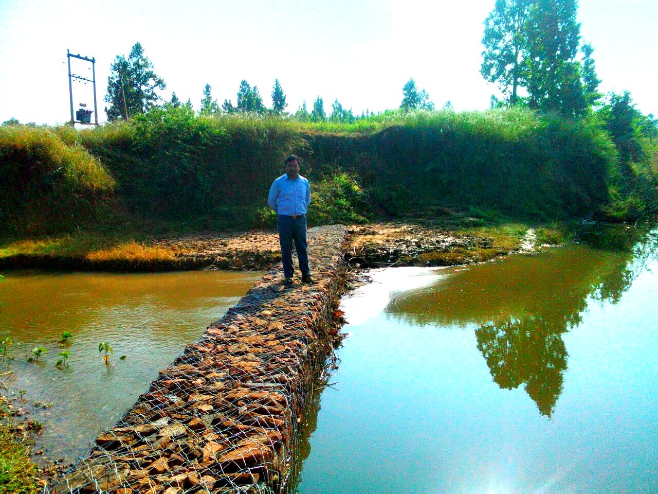
On complete assessment of drainage system of the village it was found that there was tremendous volume of water that had been running off. Four points on the main drain called Bajarmara nala, were identified as the sites for checkdams construction. Despite people were involved from the beginning, they were suspicious whether the checkdams could succeed to harvest the water. Even then they proved pluralism within the community. Five earthen and 2 masonry checkdams were constructed at such an appropriate distances that filled water in one dam touches another built upstream.
Close observation revealed that the upland forest had hundreds of the gullies, some of them as large as the ravines, which were the source of thousand of tons of soil eroded each year. This was shocking. SGVS then chased the local Forest Department after extensive advocacy in 1994-95, and the Department agreed upon to give employment to the people in the gully plugging, staggered trenches and contour bunding in the forest area. Thus far, they were senselessly involved in repeatedly widening/ repairing the main forest road. Resultantly, 65 hectares of forestland upstream (in 244 Manpur compartment no. 6) was treated. In the forest ridge, 47 gullies were plugged, and 8,000 staggered trenches were dug and 3 contour bunds were constructed.
Another innovative technique was also applied in the forest area upstream to reduce the velocity of the runoff. Water of the Bajarmara drain was diverted in the forest area towards the upland. For it a micro checkdam was built on the upstream of Bajarmara nala. The water then diverted along the elongated curved upland field in which 3 contour bunds were built parallel to one another. One such field amid two contour bunds has 8,000 staggered trenches, and remaining two fields are gently sloppy. This retained the rainwater and stopped completely the soil erosion and ravine formation.
After the construction of dam no. 3 which inundated the link road to Bajarmara hamlet especially in monsoon season, the problem was realized and various attempts were made to rectify this problem by government funds. Following the order of District Collector, Mr. R. K. Chaturvedi, after his personal visit on 8th June 1997, Rural Engineering Services submitted an estimate of Rs. 6.90 lakh for constructing a culvert. For the same work SGVS demanded Rs. 90,000 only, which was not provided directly to SGVS. Later under Community Watershed Package Programme, SGVS got the culvert constructed in such a manner that the culvert may retain rainwater when required upto the height of culvert (1 m from nala bed). The same culvert was also constructed as innovative structure that should act as water harvesting structure too. Important is that the total expenditure incurred on this culvert was Rs. 1,01,604, of what Rs. 31,820 were contributed by the villagers as the cost of labour, sand and other material
There was a singlemost pond in the village measuring 1 ha. It was lying almost defunct, and the people did not have notice of it. Although the water in the village become abundant, but the renovation of this stagnant water body was considered necessary. Before renovation started in 1999, this community resource was taken over by unwanted vegetation, siltation and drudging. It became the sanitary fill for the village. Renovation was taken off by SGVS and digging, bunding, and beautification by vegetation/ trees was carried over. This pond now supports cattle drinking and pisciculture.
There may hardly be any watershed development site in the country where results started to appear within the first year of programme implementation. In the summer season of the first year, 10 ft rise in groundwater level was recorded as a consequence of water conservation measures taken. In the reservoirs created upstream of the four different earthen checkdams as a whole 2,15,250 cum water is harvested at a time. On the other side, in gullies plugged in upland forest area, total 61,030 cum water is being stored. Thus, cumulatively, 2,76,280 cum water is harvested at a time in Rajkheta micro watershed, which greatly impacted the groundwater rise that is recorded, at the end of tail, 40 ft approximately.
Water reservoirs of the dams have no objective of irrigation. In the rabi season of 1999-2000, the electricity failures in the village caused irrigation problem during the peak time of crop. People then decided to draw the water from dam reservoirs with the help of mobile pumps, and about 60-70 acres of lands were irrigated. That year people realized the direct irrigation benefits from reservoir waters.
Tremendous volume of water, especially the groundwater, fetched the thirsty fields all across the village. Recorded 40-ft rise in groundwater table led farmers draw the water, both for drinking and irrigation purposes, by installing tube wells, or by fixing an electric diesel pump set on the open well.
Impact on the groundwater regime can also be assessed from the fact that before 1996, about 40 – 50 ft was the normal depth of the open wells, but now it has reduced to merely 20-30 ft. Rough estimates disclose that more or less 100 open wells were harvested during the summer of the year 2000 with the help of pump sets. Last but not least, the pond renovation, that included desilting, bunding, vegetating, etc. further added 100 cum water which was in actual, through the pond has total capacity of 2,500 cum water at full TL.
To harvest the groundwater for irrigation purpose, Watershed Committee has installed 7 tube wells at appropriate distances, although 3 farmers have installed their own tube wells and the government 2 tube wells. In the village, 7 pani panchyats (water user groups) do manage the water distribution affairs. Each pani panchayat is constituted by user farmers who elect president, secretary and treasurer of the group. Pani panchayat, though works under Watershed Committee, decides who would be given the water. Normally every farmer member is given water for 1 acre each in the first round. The same is repeated in second and third rounds. Each tubewell is being looked after by an operator who controls the distribution of the water and keeps the record. The revenue generated is deposited to the Watershed Committee which spends it on the maintenance of tubewells, channels, etc. The operator is being provided with the commission of Rs. 3 per hour on sold water hours.
The prosperity that appeared as a consequence of water availability may be guessed from the case of Ramdass Korwa. Ramdass Korwa now has lush green cropfields growing wheat as well as paddy. After bunding of cropfields and the onset of irrigation, he grows 2 crops in a year. In the year 2000 he yielded 15-16 quintals wheat in 2 acres of land. Under the intervention of SGVS he bunded his fields properly, and gradually his family status changed. He installed a pump set on the open well which he bought for Rs. 2,000 drawn from SHG no. 3 as a loan that he has already refunded. Ramdass recalled that such prosperity came after SGVS started watershed development programme. He further lamented, “earlier there was scarce water in the wells. In the summer, the wells used to spell dry. Very few wells had at least 7-8 ft water in this scorching heat, even when I have irrigated 2 acres of land”. A visible change in the family’s lifestyle could also be seen. Ramavtar, son of Ramdass, has got married thrice. House and the sanitation there are also changed. Household assets include television, motorcycle, bicycle, etc. The family has no debt yet to be paid. Not only the respect in the village has multiplied but the boldness and confidence into the behaviour of the family members have also magnified. Anoter farmer, Mr. Ramnath Gond recalled, "Since the advent of SGVS here, our thinking has unanimously changed. Take my example. Although I was progressive from the beginning, I had to cultivate only 100 ft2 for the vegetables, but now I grow the vegetables at least in 1 acre of land. That too, different types of vegetables are grown in summer. It could only become possible when the water is abundant in the well/ tubewell, and particularly because of the efficient functioning of Input Supply Centre. By 2000 and 2001, I had grown paddy in summer with a respective yield of 30 quintals and 25 quintals, wheat in 4 acres of land, and a huge amount of pea. I still store 1 quintal of pea. From my incomes I rebuilt the house and brought a he-buffalo".
During 1995-96 the total land area under cultivation in the rabi season was merely 30 acres, of which 13 acres was irrigated and 17 acres was rainfed. Thus the sown area in rabi season during 1995-96 was estimated to be 5% of the total cultivable land area in the village. Within 3 years of intervention of SGVS, the net sown area in rabi season during 1998-99 increased to 50% of the total land area. Similarly the sown area in kharif season had been 70% during 1995-96 which jumped to 98% in 1998–99. Another change, moreover, is observed that paddy cultivation increased from 10% in 1995-96 to 33% in 1998-99. Likewise a considerable increase is also noted in wheat, maize, barley and other crops.
Cropping pattern in the village has also changed considerably. According to the survey based on 73 farmers, the wheat seed sown additionally in 1998 was 1,346 kg. Similarly the quantum of seed of other crops also increased over a period of 3 years. Crop yields per acre have considerably increased in Rajkheta since 1995-96. Though it was not an effort to enhance the production as the modern market system demands, it is still very much subsistence agriculture but it has brought prosperity. The farmers are not in such scarcities that they could be entrapped in indebtedness. Where there was not enough foodgrain to eat for a month, thinking of the vegetable cultivation was just out of question. People were bound to buy the vegetables from the market if so needed. As the time passed by, water level in the open wells ascended, the people initiated growing vegetables in the backyard or farmyard for household consumption. Till the arrival of 1998 they even sold the vegetables in weekly local market.
In modern times of crises, though most of them are anthropogenic, we still run away from the realities. Water scarcities and droughts have been increasingly entering the veins of every corner of the country to dry up the human bloods. Responding to the crises we seek solutions in the high-cost hydro development projects or in linking the rivers, perhaps for ensuring prolific business for transnational corporations that will no longer claim their ownership and control over natural inland or marine waters of the developing countries. Underlying the misplaced thinking the irony is that despite the solution of the water crises inherently exists in the fact that "catch the water where it falls", the governments and hydrologists search them in mega projects. The case of Rajkheta, twin with countless documented or undocumented cases, shows the way ahead how to deal with the water scarcities and droughts. It is a classical example of remarkably increasing the irrigation potential and area under irrigation by utter replenishment of groundwater aquifer. However, the irrigation can sustain only when the groundwater balance is maintained by letting it recharge through rainwater harvesting. Rajkheta is a model of small-scale irrigation that defies the forced need of large-scale irrigation projects as inevitably put forward by the mainstream hydrologists and ill governments.